Wyniki wyszukiwania
The Book of chessmen / by Alex Hammond.

- Katalog: Biblioteka szachowa
- Autor: Hammond, Alexander (1888-1962)
- Rok wydania: 1950.
- Sygnatura: Sz. 20366
Wielki atlas XVII - wiecznego świata /
- Katalog: Kartografia
- Data wydania: 1984.
- Sygnatura: A IV 102
Dziennik Józefy z Dzierzkowskich Szyrminy z lat 1833-1835 zawierający materiały do dziejów emigracji polskiej w Londynie.
- Katalog: Rękopisy
- Autor: Szyrma Józefa z Dzierzkowskich
- Miejsce i czas powstania: Londyn 1833-1835
- Sygnatura: BK 01572
Jadwiga z Zamoyskich Sapieżyna (1806–1890) George Hayter
- Katalog: Muzealia
- Tytuł : Jadwiga z Zamoyskich Sapieżyna (1806–1890) George Hayter
- Sygnatura :
- MK 03343
- MK 3343
Ekspresje =
- Katalog: Czasopisma
Improved Chart of the English Channel with the Bristol Channel and the South Coast of Ireland Including the Edge of the Bank of Soundings. Drawn from the Latest Surveys by J. S. Hobbs.
- Katalog: Kartografia
- Data wydania: 1864
- Sygnatura: M IV 314
New Chart of the Bay of Biscay with Plans of the Principal Harbours: Coast of France Drawn from Surveys of M. Beautemps Beaupre and that of Spain from Don Vincent Tofi~3no.
- Katalog: Kartografia
- Data wydania: 1852
- Sygnatura: M IV 310
Chart of the White Sea Constructed from the Surveys, Made by Order of the Russian Government under the Direction of Captain Lieutenant Reinecke Revised with Additions and Improvements.
- Katalog: Kartografia
- Data wydania: 1863
- Sygnatura: M IV 311
Werstern Portion of the Mediterranean Sea Compiled from the Most Recent Surveys.
- Katalog: Kartografia
- Data wydania: 1864
- Sygnatura: M IV 312
Gulf of Bothnia Compiled from the Latest Surveys by J. S. Hobbs.
- Katalog: Kartografia
- Data wydania: 1863
- Sygnatura: M IV 313
Chart of the Coast of France from Brehat Island to Brest with Enlarged Plans of the Principal Harbours and Roadssteads Drown from the Late French Surveys by J. S. Hobbs.
- Katalog: Kartografia
- Data wydania: 1863
- Sygnatura: M IV 315
East Coast of England from Dungeness to Newcastle in four sheets Drawn from the Late French Surveys by J. S. Hobbs.
- Katalog: Kartografia
- Data wydania: 1864
- Sygnatura: M IV 316
Black Sea, etc. Chiefly from the Russian Surveys Compiled by J. S. Hobbs.
- Katalog: Kartografia
- Data wydania: 1863
- Sygnatura: M IV 317
Atlas de la Monarchie Prussienne.
- Katalog: Kartografia
- Data wydania: 1788 [rz.]
- Sygnatura: A IV 081
Road map of Great Britain with 50 mini plants of town centres.
- Katalog: Kartografia
- Data wydania: 1968]
- Sygnatura: M III 744
Bacon's new extended map of London and illustrated guide. [...]. With a large scale plan of the City [...].
- Katalog: Kartografia
- Data wydania: 20 w.
- Sygnatura: A I 185
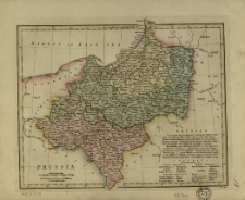
Prussia /
- Katalog: Kartografia
- Data wydania: 1814
- Sygnatura: M II 302
Chart of the Coasts of Great Britain, Ireland, France, Spain. Portugal. Showing the Whole Navigation from the Feroe and Orkney Isles to Gibraltar , Barcelona, Algiers. Revised and Materialty Improved from the Latest English, French and Spanish Surveys by J. S. Hobbs.
- Katalog: Kartografia
- Data wydania: 1863
- Sygnatura: M IV 318
Stanford's Library Map of North America constructed by A. Keit'h Johnston
- Katalog: Kartografia
- Data wydania: 1863
- Sygnatura: M IV 029
Chart of the West Indies and Spanish dominions in North America. By A. Arrowsmith.
- Katalog: Kartografia
- Data wydania: 1803
- Sygnatura: S 12

Wyświetlono rekordy 1-20 z 64