Search Results
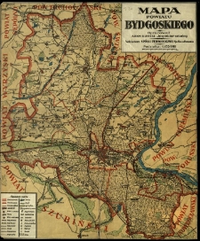
Mapa powiatu bydgoskiego.
- Library catalog: Maps
- Creation date : [1925 ca]
- ID: M II 093
Województwo bydgoskie.

- Library catalog: Maps
- Creation date : 1955
- ID: A III 083
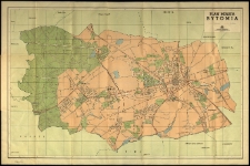
Plan miasta Bytomia.
- Library catalog: Maps
- Creation date : 1957
- ID: M III 639
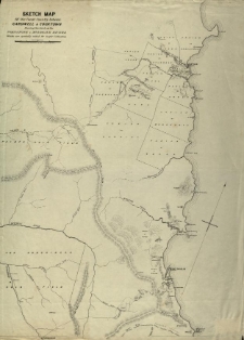
Sketch map of the coast country between Cardwell and Cooktown shewing the lands on the Johnstone and Mulgrave rivers which are specially suied for sugar cultivation.
- Library catalog: Maps
- Creation date : 1880
- ID: M III 147
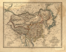
Harte der Kaiserthümer China und Japan für den Schulgebrauch entworfen und bearbeitet.
- Library catalog: Maps
- Creation date : [1830 ca]
- ID: M II 042
Chiny i Mongolia.
- Library catalog: Maps
- Creation date : 1957
- ID: A III 084
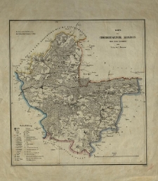
Karte des Chodziesener Kreises Regr. Bezk. Bromberg.
- Library catalog: Maps
- Creation date : 1839
- ID: M III 021
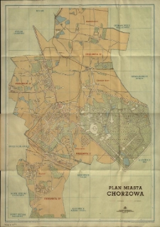
Plan miasta Chorzowa.
- Library catalog: Maps
- Creation date : 1958
- ID: M III 616
Mapa szańców w okolicy Ciepłego i Gniewu w Prusach Królewskich.
- Library catalog: Maps
- Creation date : [1879 ca]
- ID: M II 234
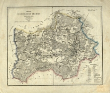
Karte des Czarnikauer Kreises Regr. Bezk. Bromberg. Nowack gez. H. Delius lith.
- Library catalog: Maps
- Creation date : 1839
- ID: M III 018
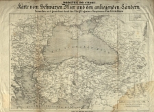
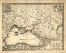
Karte vom Schwarzen Meer und den anliegenden Ländern. Entworf. u. gez. durch [...] von Grumbkow.
- Library catalog: Maps
- Creation date : [1850 ca]
- ID: M III 084
Pontus Euxinus et quae adjacent. [Karl Spruner von Merz]. C. Stier sc.
- Library catalog: Maps
- Creation date : [1837]
- ID: M III 162
Školsky atlas československych dejin.
- Library catalog: Maps
- Creation date : [1967]
- ID: A III 171
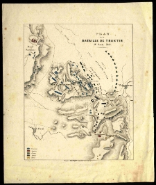
Plan de la bataille de Traktir, 16 aout 1855.
- Library catalog: Maps
- Creation date : [1880 ca]
- ID: M I 068
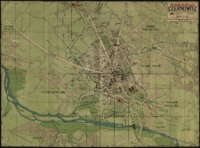
Pharus - Plan Czernowitz.
- Library catalog: Maps
- Creation date : [1910 ca]
- ID: M III 174
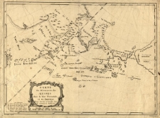
Carte des decouverts des Russes dans la Mer Orientale et en Amerique. Pour servir à l'assai sur le commerce de la Russie. Gerardin scripsit. Croisey sclupsit.
- Library catalog: Maps
- Creation date : [1750 ca]
- ID: M III 281
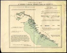
Linguistic map of Venezia Tridentina, Venezia Giulia and Dalmatia.
- Library catalog: Maps
- Creation date : [1900 ca]
- ID: M I 050
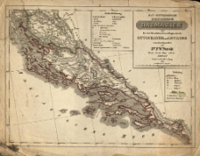
Das Oestreichische Koenigreich Dalmazien und die zwei Kroatischen Grenz-Regimenter der Ottochaner und Liccaner /
- Library catalog: Maps
- Creation date : 1835
- ID: M II 076
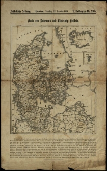
Karte von Dänemark und Schleswig-Holstein.
- Library catalog: Maps
- Creation date : 1863
- ID: M II 019
Helespont ou detroit des Dardanelles pour servir de renseignement à la carte des limites des trois empires on theatre de la guerre presente 1788
- Library catalog: Maps
- Creation date : 1788
- ID: M II 005
Viewed records 2041-2060 from 3325