Search Results
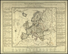
Neue Karte von Europa, welche die merkwürdigsten Produkte und vornehmsten Handelsplaetze nebst dem Flaechen Inhalt aller europaeischen Laender in deutschen Quadrat Meilen enthaelt. Verfasst von A. F. W. Crome. Neu hrsg. v on F. A. Schraembl. I. Adam sculp.
- Library catalog: Maps
- Creation date : 1787
- ID: M IV 074
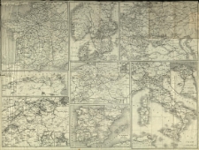
Carte des chemins de fer de l'Europe Centrale pour le Livret-Chaix continenal.
- Library catalog: Maps
- Creation date : 1900 ca]
- ID: M III 102
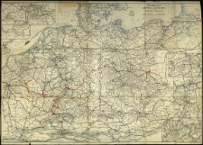
Eisenbahn-Karte von Mittel-Europa zu Hendschel's Telegraph
- Library catalog: Maps
- Creation date : [1900 ca]
- ID: M III 103
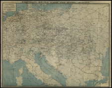
Eisenbahn-Routen-Karte von Mittel-Europa.
- Library catalog: Maps
- Creation date : 1911
- ID: M IV 031
Kriegstheater oder Graenzkarte zwischen Deutschland und Frankreich [...] Gestoch. von Franz Müller.
- Library catalog: Maps
- Creation date : [1792 ca]
- ID: M III 316
Carte elementaire et statistique de l'Allemagne [...] suivant le traite [...] de Tilsitt en 1807 [...] Par Brion et Maire [...].
- Library catalog: Maps
- Creation date : 1807
- ID: M IV 055
Staaten des deutschen Bundes, die Niederlande und die Schweiz nach der neusten Eintheilung für den Schulgebrauch bearbeitet.
- Library catalog: Maps
- Creation date : [1830 ca]
- ID: M II 033
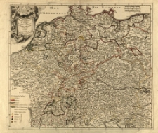
Mittel-Europa oder Nord- u. Süd-Deutschland in seiner Zukunft nach diplomatischen Aufstellungen bearb. von William Bilsy.
- Library catalog: Maps
- Creation date : [1850 ca]
- ID: M III 295
Europa. [Mapa polityczna].
- Library catalog: Maps
- Creation date : 1910 ca]
- ID: M III 277
Skelett der Übersichtskarte von Mittel-Europa im Masse 1:750 000 d. N. N.
- Library catalog: Maps
- Creation date : [1900 ca]
- ID: M II 154
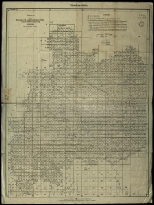
Übersicht der vom Reichsamt für Landesaufnahme Berlin im Masstabe 1:25 000 der natürlichen Länge veröffentlichen Messtischblätter (Stand: Februar 1933)
- Library catalog: Maps
- Creation date : 1933
- ID: M IV 100
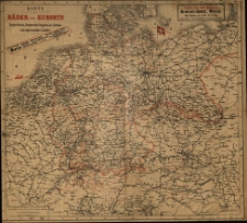
Karte der Bäder und Kurorte Deutschland, Oesterreich Ungarns, der Schweiz und angrezenden Ländern.
- Library catalog: Maps
- Creation date : [1900 ca]
- ID: M III 009
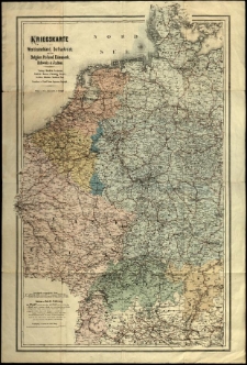
Kriegskarte von Westdeutschland, OstFrankreich, nebst Belgien, Holland, Dänemark, Schweiz und Italien [...]. Gezeichnet v. Rudolf Gross.
- Library catalog: Maps
- Creation date : [1875 ca]
- ID: M III 620
Allemagne par religions ou l'on diszingue les provinces catholiques, lutheriennes et calvinistes. Par [...] Le Rouge.
- Library catalog: Maps
- Creation date : [1850 ca]
- ID: M III 282
Staats und Verwaltungsgrenzen in Ostmitteleuropa historisches Kartenwerks.

- Library catalog: Maps
- Creation date : 1954
- ID: A III 108
Staats und Verwaltungsgrenzen in Ostmitteleuropa historisches Kartenwerks
- Library catalog: Maps
- Creation date : 1954
- ID: A III 108
Staats und Verwaltungsgrenzen in Ostmitteleuropa historisches Kartenwerks
- Library catalog: Maps
- Creation date : 1954
- ID: A III 108
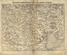
Landtafel des Ungerlands, Polands, Rüssen, Littan, Walachei und Bulgarei. [Sebastian Münster].
- Library catalog: Maps
- Creation date : 1550 ca]
- ID: M II 122
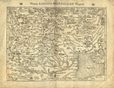
Nouva descrizzione della Polonia et dell' Ungaria. [Sebastian Münster].
- Library catalog: Maps
- Creation date : 1550 ca]
- ID: M II 113
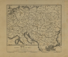
Dritter Theil der Karte von Europa welcher das südliche Russland, Polen und Ungarn die europaeische und beinahe die ganze asiatische Türkei enthaelt. Verfasst von [Jean Baptiste] d'Anville. Neu hrsg. von F. A. Schraembl.
- Library catalog: Maps
- Creation date : 1788
- ID: M IV 082


Viewed records 3081-3100 from 3325