Search Results
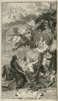
Atlas historique, ou Nouvelle introduction a l'histore, à la chronologie et à la geographie ancienne et moderne
- Library catalog: Maps
- Creation date : 1720.
- ID: A IV 022/2
Atlas historique, ou Nouvelle introduction à l'histoire, à la chronologie & à la geographie ancienne & moderne; Representee dans de Nouvelles Cartes :
- Library catalog: Maps
- Creation date : 1720.
- ID: A IV 022/3
Atlas historique, ou Nouvelle introduction à l'histoire, à la chronologie et à la geographie ancienne & moderne; Representee dans de Nouvelles Cartes,
- Library catalog: Maps
- Creation date : 1735.
- ID: A IV 022/4
Atlas historique, ou Nouvelle introduction a l'histoire, à la chronologie & à la geographie ancienne et moderne
- Library catalog: Maps
- Creation date : 1732.
- ID: A IV 022/5
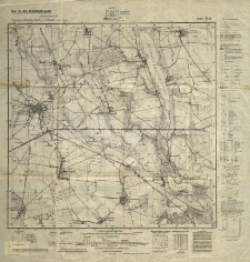
Buk. Topografische Karte.
- Library catalog: Maps
- Creation date : 1944
- ID: M III 598
China und Japan.

- Library catalog: Maps
- Creation date : 1941 12.
- ID: M I 130
Mappa Rozmiaru Gruntów Swierczyńskich i Chmielnikowskich Podług Magdeburskiey miary rozmierzonich przez Windisch. 1808.
- Library catalog: Maps
- Creation date : 1808
- ID: S 42
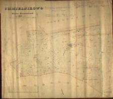
Karte von dem Vorwerke Chmielnikowo Fraustädter Kreises. Auf Grund einer Speciellen Messung im Jahre 1847 angefertigt durch Brendel Regier[ungs] Cond[ucteur].
- Library catalog: Maps
- Creation date : 1847
- ID: M IV 199
Karte von dem Vorwerke Chmielnikowo Fraustädter Kreises. Auf Grund einer Speciellen Messung im Jahre 1847 angefertigt durch Brendel Regier[ungs] Cond[ucteur].
- Library catalog: Maps
- Creation date : 1847
- ID: M IV 196
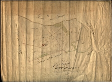
Karte Chmielnikowo [przekopiowany plan z przedstawieniem zalesienia majątku].
- Library catalog: Maps
- Creation date : 1897 ca]
- ID: M III 554
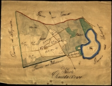
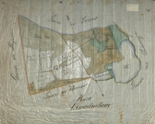
Wirtschafts-Karte von den Waldungen des Vorwerkes Chmielnikowo. Herrschaft Storchnest.
- Library catalog: Maps
- Creation date : 1860 ca]
- ID: M III 555
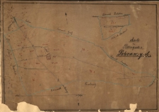
Chmielnikowo, Kreis Fraustadt, 1870. Rectificirt und copirt nach der Brendelschen Karte d. a. 1847 durch den Reg. Feldmesser Luer sen.
- Library catalog: Maps
- Creation date : 1870
- ID: M III 563
[Kopia na kalce planu pt. Chmielnikowo, Kreis Fraustadt, 1870. Rectificirt und copirt nach der Brendelschen Karte d. a. 1847 durch den Reg. Feldmesser Luer sen.].
- Library catalog: Maps
- Creation date : 1870 ca
- ID: M III 562
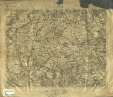
Ropczyce und Dębica. Zone 5. Col. XXV. [Spezialkarte der Österreich-Ungarischen Monarchie]
- Library catalog: Maps
- Creation date : 1882 po]
- ID: M III 533
Karte des Rittergutes Dobramysl.
- Library catalog: Maps
- Creation date : 1850 ca]
- ID: M III 557
Europa od IX-XI wieku.
- Library catalog: Maps
- Creation date : 1958
- ID: S 44
Mapa Europy środkowej z granicami państw ustalonymi na Kongresie Wiedeńskim w 1815 r.].
- Library catalog: Maps
- Creation date : 1830 ca]
- ID: M I 079
Europe.
- Library catalog: Maps
- Creation date : 19 w.
- ID: S 46
[Podróże Adama Mickiewicza].
- Library catalog: Maps
- Creation date : 1949 ca]
- ID: M IV 210
Postleitgebietskarte.
- Library catalog: Maps
- Creation date : [1940 po]
- ID: M IV 173

Viewed records 801-820 from 3325